
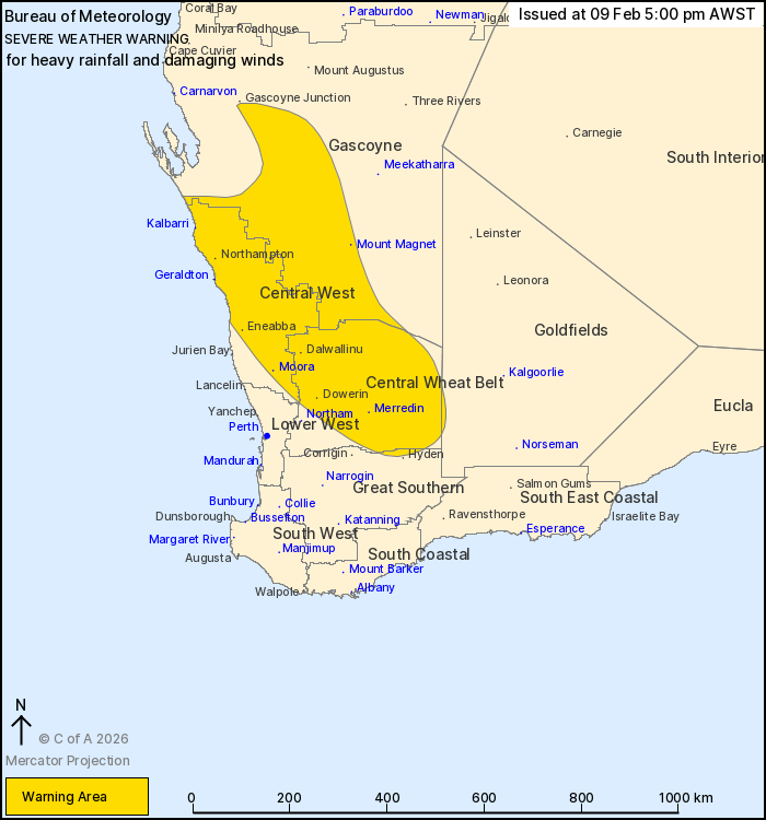
Source: Bureau of Meteorology
For people in Central West, Central Wheat Belt and parts of
Gascoyne, Goldfields, Lower West and Great Southern
districts.
Issued at 5:00 pm Monday, 9 February 2026.
Tropical Cyclone Mitchell to bring heavy rainfall and damaging
winds to the Gascoyne, Central West and Central Wheat Belt
districts from late Monday evening.
Weather Situation: Tropical Cyclone Mitchell is moving southwards
along the Gascoyne coast and is expected to turn southeast and
cross the Gascoyne coast Monday evening. It will weaken as it moves
inland overnight and transitions into an extratropical low on
Tuesday, bringing heavy rainfall and damaging winds as it tracks
inland.
HEAVY RAINFALL which may lead to FLASH FLOODING is forecast for
parts of the Gascoyne, Central West and northern parts of the
Central Wheat Belt from early Tuesday morning, especially on the
southern and western sides of the low pressure system. Six-hourly
rainfall totals between 25 and 50 mm are likely with localised
falls to 80 mm possible. 24-hour rainfall totals between 50 and 80
mm are likely with localised totals to 120 mm possible.
DAMAGING WINDS GUSTS with peak gusts to 100 km/h are possible to
the east of the low pressure system late Monday evening to Tuesday
morning before easing. DAMAGING WIND GUSTS to 90 km/h are possible
on the southern and western sides of the low pressure system from
Tuesday afternoon.
People in the north of WA may experience this type of weather each
year at this time but winds and rain may cause damage to property
and make road conditions hazardous. This type of weather is
unseasonable for people in the Central West and Central Wheat Belt
at this time of year.
Separate Tropical Cyclone and Flood Watches and/or Warnings are
current at the time of issue. Please check
https://www.bom.gov.au/weather-and-climate/warnings-and-alerts/ for
more information.
Locations which may be affected include Geraldton, Kalbarri,
Merredin, Moora, Mount Magnet and Dalwallinu.
The Department of Fire and Emergency Services advises that people
should:
* If outside find safe shelter away from trees, power lines, storm
water drains and streams.
* Close your curtains and blinds, and stay inside away from
windows.
* Unplug electrical appliances and do not use land line telephones
if there is lightning.
* If boating, swimming or surfing leave the water.
* Be alert and watch for hazards on the road such as fallen power
lines and loose debris.
* Keep away from flooded drains, rivers, streams and
waterways.
* Be careful of fallen trees, damaged buildings and debris.
* Be careful of fallen power lines. They are dangerous and should
always be treated as live.
* Assess your home, car and property for damage.
* If damage has occurred take photos and contact your insurance
company to organise permanent repairs.
* If your home or property has significant damage, like a badly
damaged roof or flooding, call the SES on 132 500.
09/Feb/2026 09:48 AM


