Source: Bureau of Meteorology
Issued at 6:02 am WST on Wednesday 12 February 2025
Headline:
Tropical Cyclone Zelia to cause potential severe impact to the
east Pilbara coast or adjacent Kimberley coast late Thursday into
Friday.
Areas Affected:
Warning Zone
Broome to Whim Creek, including Port Hedland and not including
Broome
Watch Zone
Whim Creek to Dampier, and inland to Marble Bar
Cancelled Zone
None.
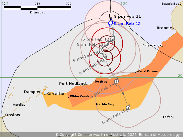
Details of Tropical Cyclone Zelia 18U at 5:00 am AWST:
Intensity: Category 1, sustained winds near the centre of 85
kilometres per hour with wind gusts to 120 kilometres per
hour.
Location: within 55 kilometres of 17.7 degrees South 119.6 degrees
East, estimated to be 280 kilometres west of Broome and 310
kilometres north northeast of Port Hedland.
Movement: south at 6 kilometres per hour.
Tropical Cyclone Zelia will move slowly to the south towards the
east Pilbara coast. Zelia is likely to develop further to category
3 intensity before crossing the east Pilbara or adjacent west
Kimberley coast most likely on Friday. The slow movement of the
system is likely to produce very high rainfall totals near the
track.
Hazards:
Gales with DAMAGING WIND GUSTS to 120 kilometres per hour may
develop along the coast between Broome (not including Broome) and
Port Hedland later Wednesday. These DAMAGING WIND GUSTS may extend
west to Dampier on Thursday, if the system moves further west than
forecast.
DESTRUCTIVE WIND GUSTS of up to 160 kilometres per hour may
develop between Bidyadanga and Port Hedland on Thursday as Zelia
moves closer to the coast.
From Wednesday night, HEAVY to LOCALLY INTENSE RAINFALL which may
lead to FLASH FLOODING becomes likely across coastal and adjacent
inland areas between Bidyadanga and Port Hedland. Otherwise
isolated HEAVY RAINFALL is forecast along the coast Broome and
Dampier. A Flood Watch is also current for catchments in the
Pilbara and western Kimberley.
Residents between Port Hedland and Bidyadanga are specifically
warned of the potential of a dangerous storm tide as the cyclone
centre crosses the coast. Tides are likely to rise significantly
above the normal high tide mark with damaging waves and dangerous
flooding.
Recommended Action:
Ensure you know what to do in a cyclone. For the latest DFES
community alerts and warnings visit www.emergency.wa.gov.au or
download the Emergency WA app.
Current
Tropical Cyclones