
Source: Bureau of Meteorology
Issued at 8:48 am WST on Thursday 13 February 2025
Headline:
Severe Tropical Cyclone Zelia intensifying and slow moving north
of Port Hedland; to bring very destructive winds and very heavy
rain to the Pilbara coast.
Areas Affected:
Warning Zone
Bidyadanga to Dampier, including Port Hedland, Karratha and
Dampier, and extending inland to Marble Bar
Watch Zone
Dampier to Mardie and inland areas to Nullagine and Tom
Price
Cancelled Zone
None.
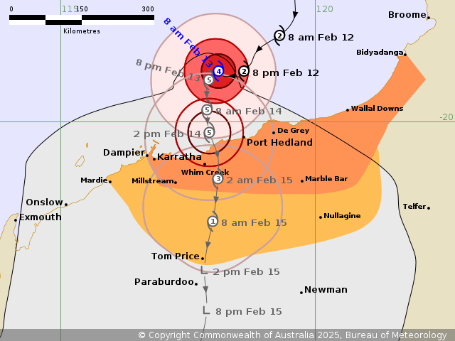
Details of Severe Tropical Cyclone Zelia 18U at 8:00 am
AWST:
Intensity: Category 4, sustained winds near the centre of 185
kilometres per hour with wind gusts to 260 kilometres per
hour.
Location: within 20 kilometres of 19.0 degrees South 118.1 degrees
East, estimated to be 155 kilometres north northwest of Port
Hedland and 235 kilometres northeast of Karratha.
Movement: slow moving.
Severe Tropical Cyclone Zelia (category 4) is intensifying rapidly
and now expected to reach category 5 intensity today. It is
forecast to remain slow moving to the north of Port Hedland today
before moving south to the coast on Friday. Zelia is forecast to
bring destructive wind gusts to communities on the Pilbara coast
from as early as later tonight but more likely Friday as Zelia
nears the coast. The very destructive inner core of the cyclone
will most likely cross the coast between Karratha and De Grey (near
Port Hedland) on Friday afternoon or night, although a later
crossing further west is possible. Heavy rainfall is expected on
the coast during the next couple of days and falls will be intense
near and to the east of the centre of the cyclone as it crosses the
coast.
Hazards:
Gales with DAMAGING WIND GUSTS to 120 kilometres per hour are
developing near the coastal fringe between De Grey and Whim Creek,
including Port Hedland. Gales may extend later today to other areas
along the coast between Bidyadanga and Dampier, including Karratha.
These DAMAGING WIND GUSTS may extend west to Mardie during Friday,
if the system moves further west. DAMAGING WIND GUSTS to 120
kilometres per hour may also extend inland to Nullagine and Tom
Price from later Friday.
DESTRUCTIVE WIND GUSTS of up to 160 kilometres per hour may
develop for coastal and island areas between Whim Creek to Wallal
Downs including Port Hedland later tonight as Zelia moves closer to
the coast. DESTRUCTIVE WIND GUSTS are more likely from Friday
between De Grey and Mardie including Karratha, Dampier and Port
Hedland as Zelia tracks towards the coast.
VERY DESTRUCTIVE WIND GUSTS of up to 290 kilometres per hour are
likely close to the centre of the cyclone as it crosses the
coast.
HEAVY to LOCALLY INTENSE RAINFALL which may lead to FLASH FLOODING
is likely during today across coastal and adjacent inland areas
between Whim Creek and Bidyadanga, extending west to Mardie and
inland to Nullagine during Friday. Otherwise isolated HEAVY
RAINFALL is also forecast along the coast between Bidyadanga and
Dampier, and inland to Nullagine today. A Flood Watch is also
current for catchments in the Pilbara, western Kimberley and
northern Gascoyne.
Residents between Karratha and Bidyadanga including Port Hedland
are specifically warned of the potential of a dangerous storm tide
as the cyclone centre crosses the coast. Tides are likely to rise
significantly above the normal high tide mark with damaging waves
and dangerous flooding of some low-lying areas close to the
shoreline.
As Zelia approaches the coast, a storm tide is expected between
Wallal Downs and Port Hedland during Thursday and into Friday.
Large waves may produce minor flooding along the foreshore. People
living in areas likely to be affected by this flooding should take
measures to protect their property as much as possible and be
prepared to help their neighbours.
Recommended Action:
Ensure you know what to do in a cyclone. For the latest DFES
community alerts and warnings visit www.emergency.wa.gov.au or
download the Emergency WA app.
Current
Tropical Cyclones
13/Feb/2025 01:08 AM


