
Source: Bureau of Meteorology
Issued at 5:43 am WST on Friday 14 February 2025
Headline:
Severe Tropical Cyclone Zelia moving towards Port Hedland.
Areas Affected:
Warning Zone
Wallal Downs to Dampier, including Port Hedland, Karratha and
Dampier, and extending inland to Marble Bar, Millstream, Nullagine,
Tom Price and Paraburdoo.
Watch Zone
None.
Cancelled Zone
Dampier to Mardie, and inland areas to Pannawonica.
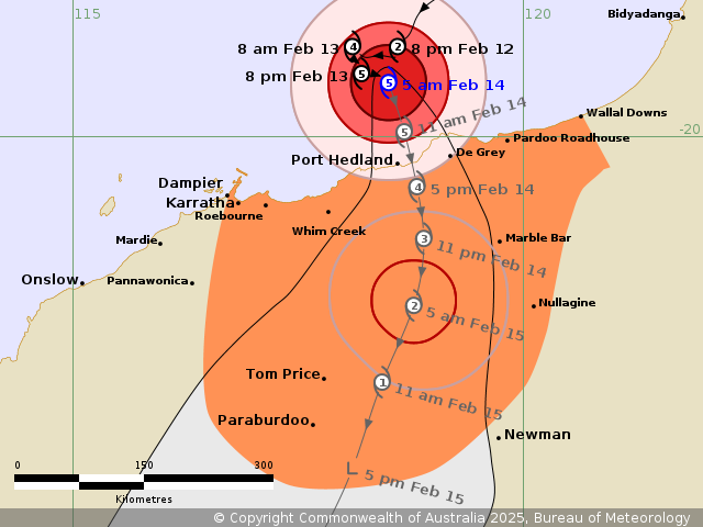
Details of Severe Tropical Cyclone Zelia 18U at 5:00 am
AWST:
Intensity: Category 5, sustained winds near the centre of 205
kilometres per hour with wind gusts to 285 kilometres per
hour.
Location: within 20 kilometres of 19.4 degrees South 118.5 degrees
East, estimated to be 100 kilometres north of Port Hedland and 225
kilometres northeast of Karratha.
Movement: east southeast at 6 kilometres per hour.
Severe Tropical Cyclone Zelia (category 5) is to the north of Port
Hedland and has started moving south towards the Pilbara coast. The
very destructive inner core of the cyclone will cross the coast
between De Grey and Whim Creek, most likely during Friday
afternoon. Heavy rainfall is expected on the coast during Friday.
Rainfall will become intense near and to the east of the centre of
the cyclone as it crosses the coast.
Hazards:
VERY DESTRUCTIVE WIND GUSTS of up to 320 kilometres per hour are
likely close to the centre of the cyclone as it crosses the
coast.
DESTRUCTIVE WIND GUSTS of up to 160 kilometres per hour are likely
to develop in coastal areas between De Grey to Whim Creek,
including Port Hedland, during Friday morning as Zelia moves closer
to the coast.
Gales with DAMAGING WIND GUSTS to 120 kilometres per hour are
occurring near the coastal fringe between De Grey and Whim Creek,
including Port Hedland. Gales may extend to other areas along the
coast between Wallal Downs and Dampier, including Karratha, during
Friday morning. DAMAGING WIND GUSTS to 120 kilometres per hour may
also extend to inland areas, possibly including Nullagine, or Tom
Price and Paraburdoo, from early Saturday.
HEAVY to LOCALLY INTENSE RAINFALL which may lead to FLASH FLOODING
is likely during Friday across coastal and adjacent inland areas
between Wallal Downs and Karratha, extending inland to Nullagine
and Tom Price by early Saturday. A Flood Watches and Warnings are
also current for catchments in the Pilbara, western Kimberley and
northern Gascoyne. Go to www.bom.gov.au/wa/warnings for further
details.
Residents between Wallal Downs and Wickham including Port Hedland
are specifically warned of the potential of a DANGEROUS STORM TIDE
as the cyclone centre crosses the coast. Tides are likely to rise
significantly above the normal high tide mark with damaging waves
and dangerous flooding of some low-lying areas close to the
shoreline.
Current
Tropical Cyclones
13/Feb/2025 10:03 PM


