
Source: Bureau of Meteorology
Issued at 8:46 pm WST on Saturday 8 February 2025
Headline:
Developing tropical low near Kimberley coast potentially becoming
a tropical cyclone on Monday.
Areas Affected:
Warning Zone
None.
Watch Zone
Cockatoo Island to Bidyadanga, including Broome.
Cancelled Zone
Kuri Bay to Cockatoo Island .
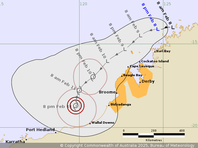
Details of Tropical Low 18U at 8:00 pm AWST:
Intensity: Tropical Low, sustained winds near the centre of 35
kilometres per hour with wind gusts to 85 kilometres per
hour.
Location: within 65 kilometres of 14.1 degrees South 124.7 degrees
East, estimated to be 505 kilometres north northeast of Broome and
155 kilometres north of Kuri Bay.
Movement: west southwest at 9 kilometres per hour.
A tropical low is forming near the north Kimberley coast. The low
is forecast to move southwest off the Kimberley coast and develop,
potentially reaching cyclone intensity by Monday. The system is
then forecast to move further to the southwest towards the Pilbara
coast.
Hazards:
Gales with DAMAGING gusts to 100 kilometres per hour may develop
near the Kimberley coast between Cockatoo Island and Beagle Bay
from early Monday, possibly extending further towards Broome and
Bidyadanga during Monday.
Locally heavy falls are possible near the Kimberley coast between
Broome and Cockatoo Island from Sunday potentially becoming more
widespread on Monday.
Abnormally high tides are possible from Sunday night between Cape
Leveque and Kuri Bay, but the sea level should not exceed the
highest tide of the year.
Recommended Action:
Ensure you know what to do in a cyclone. For the latest DFES
community alerts and warnings visit www.emergency.wa.gov.au or
download the Emergency WA app.
Current
Tropical Cyclones
08/Feb/2025 01:11 PM


