
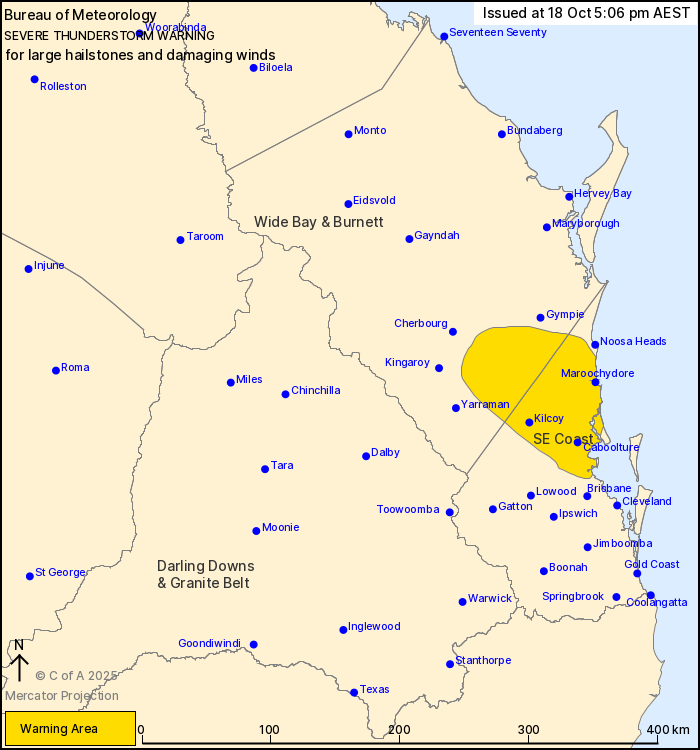
Source: Bureau of Meteorology
For people in parts of Wide Bay and Burnett and Southeast Coast
Forecast Districts.
Issued at 5:06 pm Saturday, 18 October 2025.
Severe thunderstorm north of Brisbane moving towards the Sunshine
Coast hinterland.
Weather Situation: A southeasterly change is moving through
southeast Queensland, bringing severe thunderstorms.
Severe thunderstorms are likely to produce large hailstones and
damaging winds in the warning area over the next several hours.
Locations which may be affected include Maroochydore, Caboolture,
Kilcoy, Caloundra, Nambour, Woodford, Cooroy and Imbil.
Severe thunderstorms are no longer occurring in the Darling Downs
and Granite Belt district and the warning for this district is
CANCELLED.
5 CM HAIL WAS OBSERVED AT SAMFORD AROUND 4:35 PM.
3 to 4 cm hail was observed at Cedar Grove around 4:15 pm.
2 to 3 cm hail was observed near Mt Lindesay around 4:00 pm.
2 cm hail was observed at Collingwood Park around 4:00 pm.
3 to 4 cm hail was observed east of Rathdowney around 3:50
pm.
Emergency services advise people to:
* Park your car undercover away from trees.
* Close doors and windows.
* Keep asthma medications close by. Storms and wind can trigger
asthma attacks.
* Charge mobile phones and power banks in case the power goes
out.
* Put your pets somewhere safe and make sure they can be
identified in case they get lost.
* Do not drive now unless you have to because conditions are
dangerous.
* Tell friends, family and neighbours in the area.
* Go inside a strong building now. Stay inside until the storm has
passed.
18/Oct/2025 07:10 AM


