
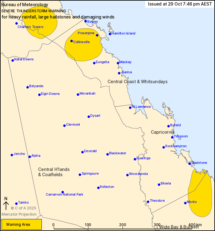
Source: Bureau of Meteorology
For people in parts of Herbert and Lower Burdekin, Central Coast
and Whitsundays, Capricornia, Wide Bay and Burnett, Northern
Goldfields and Upper Flinders and Central Highlands and Coalfields
Forecast Districts.
Issued at 7:46 pm Wednesday, 29 October 2025.
Severe thunderstorms continuing about central Queensland.
Weather Situation: Severe thunderstorms are continuing in a moist
unstable airmass. Storms are expected to slowly weaken over the
next several hours.
Severe thunderstorms are likely to produce heavy rainfall that may
lead to flash flooding, large hailstones and damaging winds in the
warning area over the next several hours. Locations which may be
affected include Proserpine, Collinsville, Mingela, Clare and
Miriam Vale.
4 cm hail was reported at Peeramon around 3:30 pm.
60.0 mm of rain was recorded at Rowallan Park in the 30 minutes to
3:19 pm.
3 cm hail was reported at Malanda around 3:00 pm.
Emergency services advise people to:
* Park your car undercover away from trees.
* Close doors and windows.
* Keep asthma medications close by. Storms and wind can trigger
asthma attacks.
* Charge mobile phones and power banks in case the power goes
out.
* Put your pets somewhere safe and make sure they can be
identified in case they get lost.
* Do not drive now unless you have to because conditions are
dangerous.
* Tell friends, family and neighbours in the area.
* Go inside a strong building now. Stay inside until the storm has
passed.
29/Oct/2025 09:59 AM


