
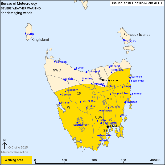
Source: Bureau of Meteorology
For people in Western, Upper Derwent Valley, South East, East
Coast, Central Plateau, Midlands and parts of North East, North
West Coast and Central North Forecast Districts.
Issued at 10:34 am Saturday, 18 October 2025.
Damaging winds developing over much of Tasmania from early
Sunday.
Weather Situation: Vigorous northwesterly flow is expected to
develop over Tasmania ahead of a cold front on Sunday bringing
damaging winds to much of the state from the early morning and into
the evening. These will turn westerly and begin to ease from the
west through Sunday evening before a second cold front brings
damaging winds from around sunrise Monday.
For ELEVATED TERRAIN: DAMAGING NORTHWESTERLY WINDS averaging 60 to
70 km/h with peak gusts of around 110 km/h are likely to develop
from early Sunday morning.
For REMAINDER OF WARNING AREA, including HOBART: DAMAGING
NORTHWESTERLY WIND GUSTS around 100 km/h are possible from early
Sunday morning.
Winds are expected to temporarily ease throughout from Sunday
evening before a second system brings another severity risk around
sunrise on Monday.
Locations which may be affected include St Helens, Swansea,
Strahan, New Norfolk, Hobart and Oatlands.
The State Emergency Service advises that people should:
* Supervise children closely.
* Check that family and neighbours are aware of warnings.
* Manage pets and livestock.
* Secure outdoor items including furniture and play
equipment.
* Be prepared in case of power outages and report any outages to
TasNetworks on 132 004.
* Beware of damaged trees and power lines and take care when
driving.
* Listen to the ABC radio or check www.ses.tas.gov.au for further
advice.
* For emergency assistance contact the SES on 132500.
17/Oct/2025 11:40 PM


